Classification workflow
The classification workflow combines classifier fitting, map prediction and accuracy assessment.
Usage:
Start the algorithm from the Processing Toolbox panel.
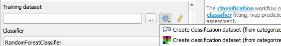
Select a training dataset or create one by clicking the processing algorithm icon and choosing one of the options.
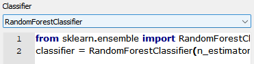
Select a classifier from the drop down menu and adjust its parameters if needed.
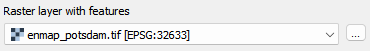
Select the raster to process and click run.
Live Demonstration:
Parameters
- Training dataset [file]
Training dataset pickle file used for fitting the classifier.
- Classifier [string]
Scikit-Learn Python code specifying a classifier.
- Raster layer with features [raster]
A raster layer used for prediction.
- Match classifier features and raster bands by name [boolean]
Whether to match raster bands and classifier features by name.
Default: False
- Number of cross-validation folds [number]
The number of folds used for assessing cross-validation performance.
Default: 10
- Open output report in webbrowser after running algorithm [boolean]
Whether to open the output report in the web browser.
Default: True
Outputs
- Output classifier [fileDestination]
Pickle file destination.
- Output classification layer [rasterDestination]
Raster file destination.
- Output class probability layer [rasterDestination]
Raster file destination.
- Output classifier performance report [fileDestination]
Report file destination.
Command-line usage
>qgis_process help enmapbox:ClassificationWorkflow:
----------------
Arguments
----------------

dataset: Training dataset
    Argument type:  file
    Acceptable values:
            - Path to a file
classifier: Classifier
    Argument type:  string
    Acceptable values:
            - String value
            - field:FIELD_NAME to use a data defined value taken from the FIELD_NAME field
            - expression:SOME EXPRESSION to use a data defined value calculated using a custom QGIS expression
raster: Raster layer with features (optional)
    Argument type:  raster
    Acceptable values:
            - Path to a raster layer
matchByName: Match classifier features and raster bands by name (optional)
    Default value:  false
    Argument type:  boolean
    Acceptable values:
            - 1 for true/yes
            - 0 for false/no
            - field:FIELD_NAME to use a data defined value taken from the FIELD_NAME field
            - expression:SOME EXPRESSION to use a data defined value calculated using a custom QGIS expression
nfold: Number of cross-validation folds (optional)
    Default value:  10
    Argument type:  number
    Acceptable values:
            - A numeric value
            - field:FIELD_NAME to use a data defined value taken from the FIELD_NAME field
            - expression:SOME EXPRESSION to use a data defined value calculated using a custom QGIS expression
openReport: Open output report in webbrowser after running algorithm (optional)
    Default value:  true
    Argument type:  boolean
    Acceptable values:
            - 1 for true/yes
            - 0 for false/no
            - field:FIELD_NAME to use a data defined value taken from the FIELD_NAME field
            - expression:SOME EXPRESSION to use a data defined value calculated using a custom QGIS expression
outputClassifier: Output classifier
    Argument type:  fileDestination
    Acceptable values:
            - Path for new file
outputClassification: Output classification layer (optional)
    Argument type:  rasterDestination
    Acceptable values:
            - Path for new raster layer
outputProbability: Output class probability layer (optional)
    Argument type:  rasterDestination
    Acceptable values:
            - Path for new raster layer
outputClassifierPerformance: Output classifier performance report (optional)
    Argument type:  fileDestination
    Acceptable values:
            - Path for new file

----------------
Outputs
----------------

outputClassifier: <outputFile>
    Output classifier
outputClassification: <outputRaster>
    Output classification layer
outputProbability: <outputRaster>
    Output class probability layer
outputClassifierPerformance: <outputHtml>
    Output classifier performance report