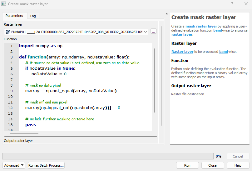
Create mask raster layer
Create a mask raster layer by evaluating a source raster layer.
Usage:
Open the algorithm from the processing toolbox.
Select a raster layer to be masked and modify the python script to fit your needs, then click run.
The output raster can be found under Rasters in the Data Source Panel
Parameters
- Raster layer [raster]
- Band [band]
Band to be evaluated.
- Mask no data values [boolean]
Whether to mask no data values. Default: True
- Mask non-finite values [boolean]
Whether to mask non-finite values (i.e. Inf and NaN). Default: True
- Mask values [matrix]
Values to be masked.
- Mask value ranges [matrix]
Value-ranges to be masked.
- Mask bits [matrix]
Bits to be masked. A bit mask part is specified by the “First bit”, the “Bit count” and a list of “Values” (space- or comma-separated) to be masked.
Outputs
- Output mask raster layer [rasterDestination]
Raster file destination.
Command-line usage
>qgis_process help enmapbox:createmaskrasterlayer:
----------------
Arguments
----------------

raster: Raster layer
    Argument type:    raster
    Acceptable values:
        - Path to a raster layer
band: Band
    Argument type:    band
    Acceptable values:
        - Integer value representing an existing raster band number
maskNoDataValues: Mask no data values (optional)
    Default value:    true
    Argument type:    boolean
    Acceptable values:
        - 1 for true/yes
        - 0 for false/no
        - field:FIELD_NAME to use a data defined value taken from the FIELD_NAME field
        - expression:SOME EXPRESSION to use a data defined value calculated using a custom QGIS expression
maskNonFiniteValues: Mask non-finite values (optional)
    Default value:    true
    Argument type:    boolean
    Acceptable values:
        - 1 for true/yes
        - 0 for false/no
        - field:FIELD_NAME to use a data defined value taken from the FIELD_NAME field
        - expression:SOME EXPRESSION to use a data defined value calculated using a custom QGIS expression
maskValues: Mask values (optional)
    Argument type:    matrix
    Acceptable values:
        - A comma delimited list of values
maskValueRanges: Mask value ranges (optional)
    Argument type:    matrix
    Acceptable values:
        - A comma delimited list of values
maskBits: Mask bits (optional)
    Argument type:    matrix
    Acceptable values:
        - A comma delimited list of values
outputMask: Output mask raster layer (optional)
    Argument type:    rasterDestination
    Acceptable values:
        - Path for new raster layer

----------------
Outputs
----------------

outputMask: <outputRaster>
    Output mask raster layer