Fit FastICA
FastICA: a fast algorithm for Independent Component Analysis.
FastICA separates a multivariate signal into additive, statistically independent components. It assumes that the sources are linearly mixed, non-Gaussian, and mutually independent.
Usage:
Start the algorithm from the Processing Toolbox panel.
Select a raster layer to process and click run.
Parameters
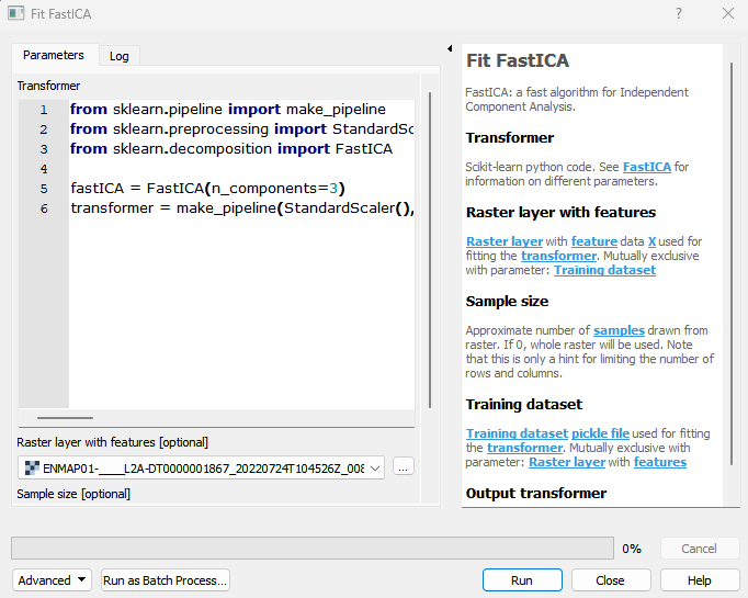
- Transformer [string]
Scikit-learn python code. See FastICA for information on different parameters. Default:
from sklearn.pipeline import make_pipeline
from sklearn.preprocessing import StandardScaler
from sklearn.decomposition import FastICA

fastICA = FastICA\(n_components=3, whiten='unit-variance'\)
transformer = make_pipeline\(StandardScaler\(\), fastICA\)
- Raster layer with features [raster]
Raster layer with feature data X used for fitting the transformer. Mutually exclusive with parameter: Training dataset
- Sample size [number]
Approximate number of samples drawn from raster. If 0, whole raster will be used. Note that this is only a hint for limiting the number of rows and columns. Default: 1000
- Training dataset [file]
Training dataset pickle file used for fitting the transformer. Mutually exclusive with parameter: Raster layer with features
Outputs
- Output transformer [fileDestination]
Pickle file destination.
Command-line usage
>qgis_process help enmapbox:fitfastica:
----------------
Arguments
----------------

transformer: Transformer
    Default value:    from sklearn.pipeline import make_pipeline
from sklearn.preprocessing import StandardScaler
from sklearn.decomposition import FastICA

fastICA = FastICA(n_components=3, whiten='unit-variance')
transformer = make_pipeline(StandardScaler(), fastICA)
    Argument type:    string
    Acceptable values:
        - String value
        - field:FIELD_NAME to use a data defined value taken from the FIELD_NAME field
        - expression:SOME EXPRESSION to use a data defined value calculated using a custom QGIS expression
featureRaster: Raster layer with features (optional)
    Argument type:    raster
    Acceptable values:
        - Path to a raster layer
sampleSize: Sample size (optional)
    Default value:    1000
    Argument type:    number
    Acceptable values:
        - A numeric value
        - field:FIELD_NAME to use a data defined value taken from the FIELD_NAME field
        - expression:SOME EXPRESSION to use a data defined value calculated using a custom QGIS expression
dataset: Training dataset (optional)
    Argument type:    file
    Acceptable values:
        - Path to a file
outputTransformer: Output transformer
    Argument type:    fileDestination
    Acceptable values:
        - Path for new file

----------------
Outputs
----------------

outputTransformer: <outputFile>
    Output transformer